-
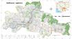
Ratanakiri communal land use planning (CLUP) atlas 2009
 Cambodia
April 18, 2017
Source: Ministry of Land Management, Urban Planning and Construction...
Cambodia
April 18, 2017
Source: Ministry of Land Management, Urban Planning and Construction...
 Ratanakiri communal land use planning(CLUP) atlas (Aekakpheap, Ka Choun, Pong, Sameaki, Serei Mongkol, and Toen commune) is communal land use planning extracted from 2009 contai...
-
Siem Reap communal land use planning (CLUP) atlas 2009
Cambodia
April 18, 2017
Source: Ministry of Land Management, Urban Planning and Construction...
 Siem Reap communal land use planning(CLUP) atlas (Chan Sar, Doun Peaeng, Leang Dai, Nokor Pheas , Popel, Srae Khvav, Svay Chek, Tayaek commune) is communal land use planning ext...
-
Kampong Speu commune land use planning (CLUP) atlas 2009
Cambodia
March 29, 2017
Source: Ministry of Land Management, Urban Planning and Construction...
Kampong Speu commune land use planning(CLUP) atlas (Kiri Vaon, Moha Sang, Honorom, Prabei Mom, Prey Khmeng, and Yea Angk commune) is communal land use planning extracted from 20...
-
Kampong Cham communal land use planning (CLUP) atlas 2009
Cambodia
April 18, 2017
Source: Ministry of Land Management, Urban Planning and Construction...
 Kampong Cham communal land use planning(CLUP) atlas (Chikor, Moung Riev, Roang, and Srak commune) is communal land use planning extracted from 2009 contained both detailed curre...
-
Mondulkiri communal land use planning (CLUP) atlas 2009
Cambodia
April 18, 2017
Source: Ministry of Land Management, Urban Planning and Construction...
 Mondulkiri communal land use planning(CLUP) atlas (Dak Dam, Pu Chri, Saen Monourom, Srae Ampum, Srae Khtum, and Srae Preah commune) is communal land use planning extracted from ...
-
Preah Sihanouk communal land use planning (CLUP) atlas 2009
Cambodia
April 18, 2017
Source: Ministry of Land Management, Urban Planning and Construction...
Preah Sihanouk communal land use planning(CLUP) atlas (Angdoung Thma, Kampenh, Outreh, Samrong, and Tomnob Rolok commune) is communal land use planning extracted from 2009 conta...
-
Kep communal land use planning (CLUP) atlas 2009
Cambodia
April 18, 2017
Source: Ministry of Land Management, Urban Planning and Construction...
Kep communal land use planning(CLUP) atlas (Angkaol, Ou Krasar, and Pong Tuek commune) is communal land use planning extracted from 2009 contained both detailed current land us...
-
Kratie communal land use planning (CLUP) atlas 2009
Cambodia
April 18, 2017
Source: Ministry of Land Management, Urban Planning and Construction...
 Kratie communal land use planning(CLUP) atlas (Dar, Kbal Damrey, O Krieng, Ruessei Kaev, Saob, Srae Char, Svay Chreah, and Thmi commune) is communal land use planning extracted ...
-
Percent forest cover by province in Cambodia (1973 - 2014)
Cambodia
April 1, 2015
Source: Open Development Cambodia. "Forest cover in Cambodia (1973 -...
The dataset describes percent forest cover by province in Cambodia in 1973, 1989, 2000, 2004, 2009, 2013 and 2014. This dataset is derived from ODC forest cover in Cambodia (197...
-
Plant and animal species in Prey Lang
Cambodia
November 7, 2016
Source: Prey Lang Community Network http://preylang.net/
Winrock...
This data consist of information about species of plants and animals living in Prey Lang forest according to Biodiversity Assessment of Prey Lang published in 2015. Those inform...
-
Thai Forest Act 1941
Thailand
April 10, 2015
Source: ThaiLaws.com (http://www.thailaws.com/body_english_acts.htm)
English translation of the Thai Forest Act of 1941
-
Urban design principles for flood resilience: Learning from the ecological wisdom of living with floods in the Vietnamese Mekong Delta
Viet Nam
December 29, 2017
Source: Kuei-Hsien Liao, Tuan Anh Le, Kien Van Nguyen (2016). Urban design...
Despite the widespread implementation of flood control infrastructure, modern cities around the world remain vulnerable to flood hazards. Although flood management has in genera...
-
LMCs - Key Dimensions of Water Security (ADB - ADWO)
Cambodia, Lao People's Democratic Republic, Myanmar, Thailand, Viet Nam
May 17, 2018
Source: ABD:...
Data on the LMCs on Key Dimensions of Water Security, developed by ADB.
-
Environmental Changes and Migration under the Forces of Climate Change in Vietnam's Mekong Delta
Viet Nam
January 5, 2018
Source: - Data collected and analyzed by the authors during their field...
 There is no doubt that the Mekong Delta is facing serious threats caused by climate change and Mekong upstream dams. In recent years, those threats have resulted in large-scale ...
-
WASH Dataset 1990-2015
Cambodia, Lao People's Democratic Republic, Myanmar, Thailand, Viet Nam
May 10, 2018
Source: ESCAP SDG data portal and JMP Data Portal.
Contains data compiled by JMP and UNESCAP on SDGs 6.1 and 6.2, including safely managed drinking water, basic hand washing facilities, safely managed sanitation, and open defeca...
-
LMCs Protected Areas Data (Protected Areas Program - UNEP)
Cambodia, Lao People's Democratic Republic, Myanmar, Thailand, Viet Nam
May 15, 2018
Source: The April 2016 version of the World Database on Protected Areas...
Summary statistics, per country, for the extent of area covered by protected areas for both terrestrial and marine realms. LMCs only.
-
Agreements Document Type
Cambodia, Lao People's Democratic Republic, Myanmar, Thailand, Viet Nam
February 20, 2017
Source: Agreements document type is determined by the ODM team.
Data used for dropdown options in the Agreements metadata forms. Definitions of each term is provided and also available within the Partner wiki https://wiki.opendevelopmentmeko...
-
Vietnam Forest Law 2004
Viet Nam
April 10, 2015
Source: Government of the Socialist Republic of Vietnam
English version of the Vietnam Forest Protection and Development Law (2004)
-
Mangrove Communities and Disaster Risk Reduction: Cases in Vietnam
Philippines, Viet Nam
December 29, 2017
Source: Le Anh Tuan and Maria Lourdes T. Munárriz (2016). Mangrove...
Mangrove forest belts have very important role on reducing the impacts of natural disasters in the coastal areas. However, in the last three decades, under the pressures of incr...
-
Urban population projections in the Lower Mekong
Cambodia, Lao People's Democratic Republic, Myanmar, Thailand, Viet Nam
March 26, 2018
Source: United Nations, Department of Economic and Social Affairs,...
Data is derived from country census complied by the United Nations, Department of Economic and Social Affairs, Population Division. The suggested citation of the original report...