| หมวดหมู่หัวข้อของชุดข้อมูล |
- Environment and natural resources
- Forest classifications
- Protected areas
- Protected forests
|
| ภาษา |
|
| วันที่ชุดข้อมูล |
19 มิถุนายน ค.ศ. 2013
|
| ชื่อทางภูมิศาสตร์ |
|
| พิกัดขอบเขตทิศตะวันตก |
102.95019449948946 |
| พิกัดขอบเขตทิศตะวันออก |
107.63939560015251 |
| พิกัดขอบเขตทิศใต้ |
10.609992063254507 |
| พิกัดขอบเขตทิศเหนือ |
14.418046557763915 |
| ระบบอ้างอิงเชิงพื้นที่ |
WGS 84 / UTM zone 48N (EPSG:32648) |
| ความแม่นยำเชิงตำแหน่ง |
There are no known issues with accuracy.
|
| ความสอดคล้องเชิงตรรกะ |
There are no known issues with logical consistency.
|
| ความสมบูรณ์ |
There are no known issues with completeness.
|
| ขั้นตอนของกระบวนการ |
Data were provided to Open Development Cambodia directly by Save Cambodia's Wildlife's 2013 Atlas Working Group in ESRI Shapefile format. The coordinate reference system was changed from WGS 84 Zone 48 N to WGS 84 and the data was exported in both ESRI Shapefile and geoJSON formats.
|
| แหล่งที่มา |
Wildlife Conservation Society, Conservation International, Forestry Administration, ASEAN Regional Center for Biodiversity, UNEP. Save Cambodia's Wildlife. "Biodiversity." Atlas of Cambodia: maps on socio-economic development and environment. Second ed. Phnom Penh, 2014. 27. Print.
|
| ฝ่ายงานรับผิดชอบ |
Conservation International, data@conservation.org, Save Cambodia's Wildlife (SCW), info@cambodiaswildlife.org, +855 23 88 20 35, http://cambodiaswildlife.org, 6Eo St.570, Sangkat Boeung Kak 2, Khan Tuol Kork, Phnom Penh, Cambodia.
|
| ข้อมูลผู้สร้างคำอธิบายชุดข้อมูล |
Metadata last updated on 2014-06-19. For inquiries contact: Open Development Cambodia, contact@opendevcam.net, +855 23 221 164, http://www.opendevelopmentcambodia.net, 43 St. 208, Sangkat Boeung Riang, Khan Daun Penh, Phnom Penh, Cambodia.
|
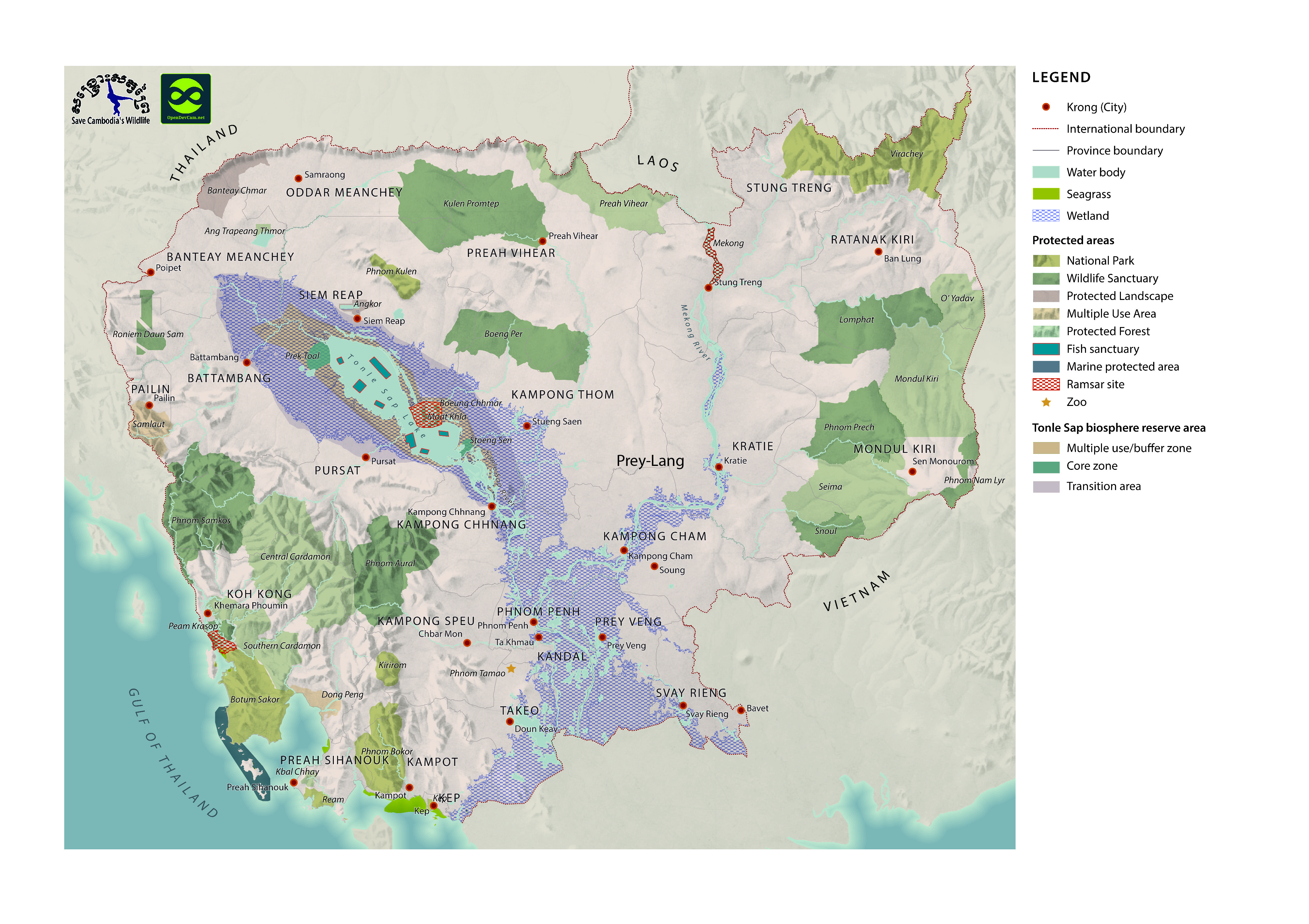
| คุณสมบัติ |
Name/WCS: Name of the protected areas, LSize_Ha/WCS: Area size (hectare), Status/WCS: National park, wildlife santuary, protected forests or multiple use area, Category/WCS: The value is \"protected forests\" if the status is protected forests, otherwise blank.
|
| สัญญาอนุญาต |
CC-BY-4.0
|
| ลิขสิทธิ์ |
No |
| เวอร์ชัน |
1.0 |
| วันที่อัพโหลด |
ธันวาคม 5, 2015, 19:39 (UTC)
|
| แก้ไขเมื่อ |
ตุลาคม 8, 2019, 16:21 (UTC)
|