Vulnerability to climate hazards (2014-2022)
พิมพ์โดย: Open Development Cambodia
ทรัพยากรข้อมูล (45)
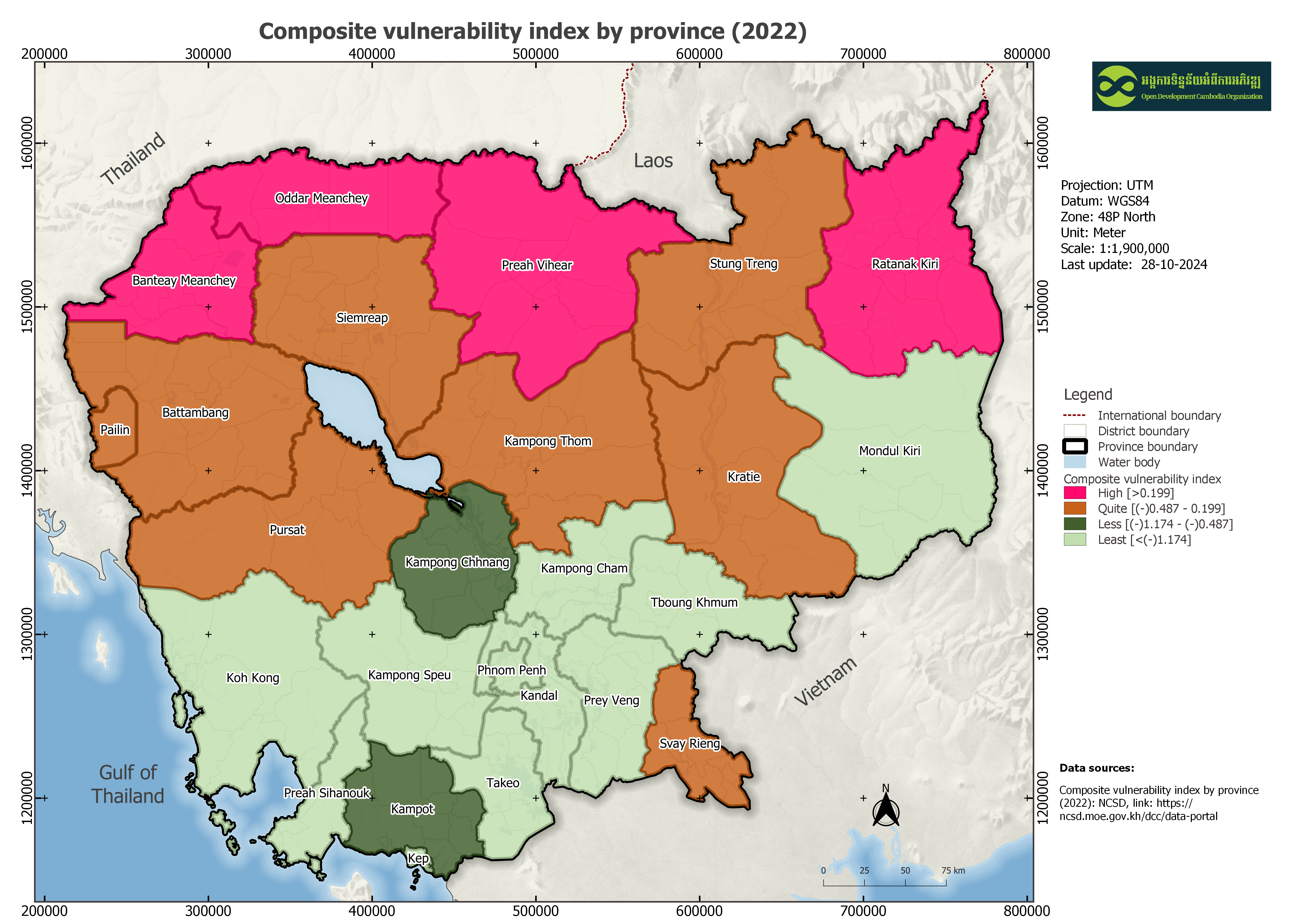
ตัวอย่างทรัพยากรข้อมูล - Vulnerability Index by province (2022)
ข้อมูลเพิ่มเติม
| ฟิลด์ | ค่า |
|---|---|
| หมวดหมู่หัวข้อของชุดข้อมูล | Climate change |
| ภาษา |
|
| ข้อจำกัดการใช้งาน | By accessing this website or database, users agree to take full responsibility for reliance on any site information provided and to hold harmless and waive any and all liability against individuals or entities associated with its development, form, and content for any loss, harm, or damage suffered as a result of its use. |
| ชื่อทางภูมิศาสตร์ |
|
| ระบบอ้างอิงเชิงพื้นที่ | WGS 84 / UTM zone 48N (EPSG:32648) |
| ความแม่นยำของคุณสมบัติ | Data attribute was extracted from the National Council for Sustainable Development (NCSD). |
| ความสอดคล้องเชิงตรรกะ | There are no known issues with logical consistency. |
| ความสมบูรณ์ | Completeness according to data source from the National Council for Sustainable Development (NCSD). |
| ขั้นตอนของกระบวนการ | This dataset originally sourced from the National Council for Sustainable Development's website, the data was converted from an Excel file format to an SQLite for provincial level before being made accessible on the Open Development Cambodia organization's website. |
| แหล่งที่มา | The National Council for Sustainable Development (NCSD): https://ncsd.moe.gov.kh/dcc/data-portal#nogo |
| ฝ่ายงานรับผิดชอบ | National Council on Sustainable Development (NCSD) Address: 3rd floor, Morodok Techo Building, Lot 503, Tonle Bassac, Chamkarmon, Phnom Penh, Cambodia Tel: +855 89 218 370 |
| ข้อมูลผู้สร้างคำอธิบายชุดข้อมูล | Metadata last updated on 2024-08-20. For inquiries contact: Open Development Cambodia Address: #23B St. 606, Phnom Penh, Cambodia. Email: contact@opendevcam.net Website: http://www.opendevcam.net |
| คุณสมบัติ | prov_code: Province code; prov_name: Province name; storm_vi: Storm vulnerability index; rank: Rank; flood_vi: Flood vulnerability index; drought_vi: Drought vulnerability index; composi_vi: Composite vulnerability index; commgis: Commune code; |
| ความถี่ในการปรับปรุง | annually |
| สัญญาอนุญาต | Creative Commons Attribution Share-Alike |
| ลิขสิทธิ์ | Yes |
| เวอร์ชัน | 1 |
| คำสำคัญ | vulnerability,flood,storm |
| วันที่อัพโหลด | สิงหาคม 20, 2024, 07:21 (UTC) |
| แก้ไขเมื่อ | ตุลาคม 28, 2024, 04:22 (UTC) |